| Category 3 (Saffir–Simpson scale) | |
 | |
| Formed | December 31, 1978 |
|---|---|
| Dissipated | January 14, 1979 |
| Highest winds |
1-minute sustained: 205 km/h (125 mph) |
| Lowest pressure | 930 hPa (mbar); 27.46 inHg |
| Fatalities | 0 |
| Damage | Extensive |
| Areas affected | Marshall Islands |
| Part of the 1979 Pacific typhoon season | |
Typhoon Alice was the first named storm of the 1979 Pacific typhoon season, as well as the first typhoon of the season. Alice caused extensive damage in the Marshall Islands, which caused the storm's name to be retired. The storm originally formed on December 31, 1978, but is labelled as "197901" on JMA's official database. Alice reached peak intensity on January 8, before dissipating on January 14, 1979. Alice was one of the southernmost forming tropical cyclones on record, forming at 2.5 degrees N.[1]
Meteorological history[]

Map plotting the track and intensity of the storm, according to the Saffir–Simpson scale.
Typhoon Alice, the first tropical cyclone of the 1979 season, was actually first sighted as a tropical disturbance on the 27th of December 1978. Being over the Gilbert Islands quite close to the equator, the potential for development was considered poor. A tropical cyclone formation alert was issued at 0300Z 1 January 1979 when satellite data showed the disturbance progressively increasing in organization. Soon after, the suspect area accelerated northwest to higher latitudes where development conditions were more favorable, and by January 1 at 1800Z, Tropical Storm Alice was named. Post-analysis showed that the tropical depression stage began on January 1 at low latitudes, contrary to the general rule that cyclones do not form close to the equator.
Although a climatologically unfavored period for western North Pacific tropical cyclone development, the fact that Alice did form supports the non-existence of a definitive “typhoon season” for WESTPAC; tropical cyclones are possible anytime of the year. The greatest forecasting difficulties and concomitant large forecast errors occurred during Alice’s formative and dissipating stages. Double intensification also contributed to Alice’s notoriety. Early in her lifetime, Alice meandered through the Marshall Islands as if determined to visit each island.
A satellite reconnaissance fix at 2133Z on January 2 showed Alice had moved northeastward when forecast to continue northwestward. Being a fix on a poorly defined satellite image, it was not taken verbatim; northwest movement continued to be forecast. An aircraft reconnaissance fix at 0053Z on January 3 confirmed the earlier satellite fix as did a follow on the January 3 aircraft fix. Post analysis revealed that a mid-latitude, shortwave trough passed north of Alice during this time period. The trough extended deep enough into the tropics to weaken the midtropospheric ridge. This weakness permitted a southward intrusion of mid-latitude westerlies into Alice’s vicinity, temporarily steering her northeastward. As the shortwave trough continued eastward, the subtropical ridge quickly reestablished itself north of Alice producing strong easterly steering flow, temporarily accelerating the system from 4 to 10 kt (8 to 19 km/hr) toward the northwest when continued northeast movement was forecast. During this time, decision makers on Enewetak (also within the Marshall Islands), noting the low forecast confidence stated on prognostic reasoning messages, kept a condition of readiness which paid off.
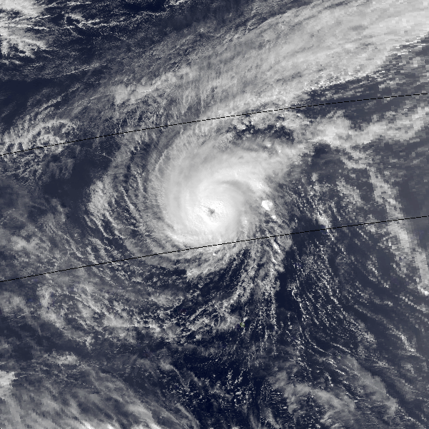
From the 6th to the 11th, Alice traveled due west. On the 8th, Alice attained 110 kt intensity and simultaneously accelerated to a speed of 14 kt (26 km/hr) (the fastest observed along track), whereupon the system began weakening slowly. During the 9th, Alice began an unexpected northward movement trend and showed further weakening. Post-analysis of low-level synoptic data and satellite imagery (Fig. 3-01-1) indicated that an approaching frontal shearline was the responsible agent. The shearline began interacting with Alice while it was southeast of Guam. As Alice neared Guam, radar data from Andersen AFB and aircraft data indicated that Alice’s previously well-defined wall cloud became larger and somewhat less organized. Cooler, drier air north of the shear-line was likely responsible for this weakening trend. A weakness in the subtropical ridge vertically above the shearline apparently allowed for Alice’s northward deviation.
Typhoon Alice at its secondary peak intensity on January 11.
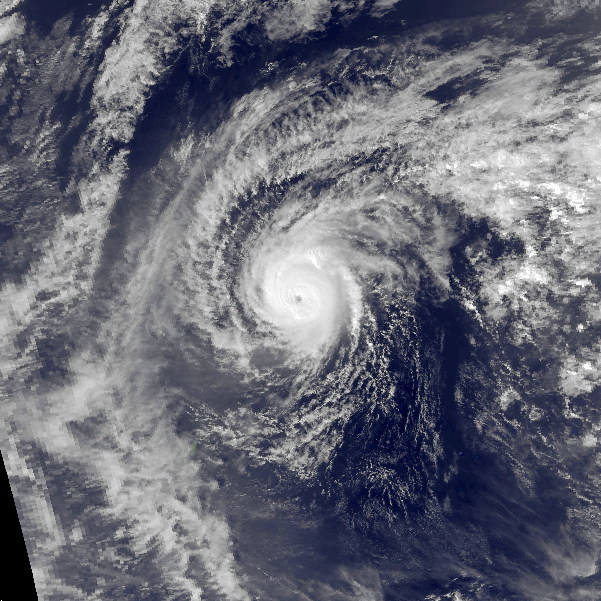
The most unusual portion of Alice’s track occurred during the final 3 days of Alice's life. Based on interpretation of PE progs, the subtropical ridge was expected to persist and maintain Alice in the easterlies. As a result, the JTWC forecasts (supported by the majority of objective forecast aids) indicated westward movement until 0000Z on January 12, 18 hours after Alice had actually begun tracking northwestward. The subtropical ridge weakened in response to a long-wave trough deepening over eastern Asia. Easterly steering currents in Alice’s vicinity diminished and veered in direction, permitting a more northward track. Alice reached a secondary intensity maximum of 100 kt (51 m/see) during this period due to her slowing in speed of movement, the increased absolute vorticity of higher latitudes and good outflow aloft.
By the 13th, Alice turned northeastward and began weakening rapidly. The subtropical ridge was now completely severed and upper air westerlies were shearing Alice significantly in the vertical. Close proximity of yet another frontal shear-line contributed to further weakening. The biggest surprise, however, came when Alice’s low-level circulation turned almost 180 degrees back toward the west at about 1200Z on January 13 under the influence of strong, low-level easterlies and weakened rapidly in the strong, vertical-shear environment. As a result of vertical decoupling, Alice as a shallow depression, dissipated during the following 12-hour period.
Impact[]
During Alice's passage, the storm was only a tropical storm. However, due to slow movement over the island nation, damage was extensive. One week after Typhoon Alice's passage, President Jimmy Carter declared the Marshall Islands as a disaster area. No fatalities were reported, and no other land areas were reported to be affected by Typhoon Alice during its lifetime. [2]
Retirement[]
During the 1979 season, male names were adopted to the naming lists. Therefore, the name Alice was no longer on the lists. The name Andy took its place to cooperate with its position on the lists.
See also[]
- Tropical Storm Bolaven (2018) - Formed in 2017 but was not designated until 2018.