2011 Atlantic hurricane season | |
---|---|
Season summary map | |
Seasonal boundaries | |
First system formed | June 28, 2011 |
Last system dissipated | November 11, 2011 |
Strongest storm | |
Name | Ophelia |
• Maximum winds | 150 mph (240 km/h) |
• Lowest pressure | 940 mbar (hPa; 27.76 inHg) |
Seasonal statistics | |
Total depressions | 20 |
Total storms | 19 |
Hurricanes | 7 |
Major hurricanes (Cat. 3+) | 4 |
Total fatalities | 299 - 100 Direct, 14 Indirect |
Total damage | ≥ $16.18 billion (2011 USD) |
| |
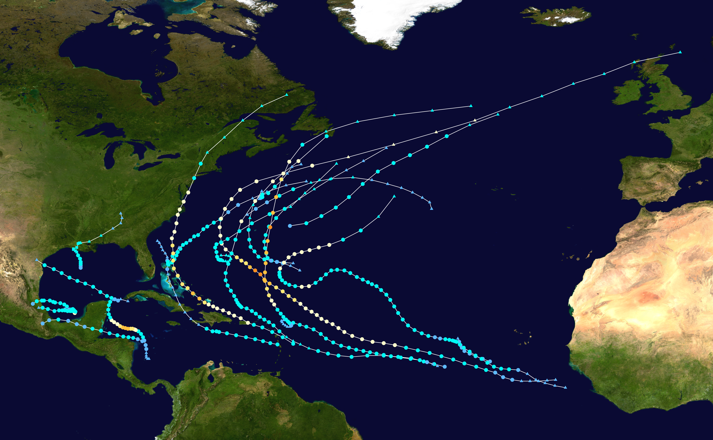
The 2011 Atlantic hurricane season was another very active season as a result of a continuing strong La Nina, though most storms were weak or short lived. This season featured a total of 20 tropical cyclones, 19 named storms, and 1 unnamed storm, 7 hurricanes, and 4 major hurricanes. This season is tied for third most active along with, 1887, 1995, 2010, and 2012. The strongest storm was Category 4 Hurricane Ophelia, that caused minimal damages.
Timeline[]
Storms[]
Tropical Storm Arlene[]
Tropical storm (SSHWS) | |||
---|---|---|---|
| |||
Duration | June 28 – July 1 | ||
Peak intensity | 65 mph (100 km/h) (1-min) 993 mbar (hPa) |
Arlene was a tropical storm over the southwestern Gulf of Mexico that made landfall along the coast of Mexico in the state of Veracruz.[1]
Tropical Storm Bret[]
Tropical storm (SSHWS) | |||
---|---|---|---|
| |||
Duration | July 17 – July 22 | ||
Peak intensity | 70 mph (110 km/h) (1-min) 995 mbar (hPa) |
Bret was a tropical storm that remained over the open ocean throughout its lifetime and briefly threatened the northern Bahamas.[2]
Tropical Storm Cindy[]
Tropical storm (SSHWS) | |||
---|---|---|---|
| |||
Duration | July 20 – July 22 | ||
Peak intensity | 70 mph (110 km/h) (1-min) 994 mbar (hPa) |
Cindy was a short-lived tropical storm that developed east of Bermuda and moved quickly northeastward over the cooler waters of the North Atlantic.[3]
Tropical Storm Don[]
Tropical storm (SSHWS) | |||
---|---|---|---|
| |||
Duration | July 27 – July 30 | ||
Peak intensity | 50 mph (85 km/h) (1-min) 997 mbar (hPa) |
Don was a tropical storm that formed in the Yucatan Channel and moved west-northwestward across the Gulf of Mexico. Don weakened to a tropical depression as it made landfall in south Texas.[4]
Tropical Storm Emily[]
Tropical storm (SSHWS) | |||
---|---|---|---|
| |||
Duration | August 2 – August 7 | ||
Peak intensity | 50 mph (85 km/h) (1-min) 1003 mbar (hPa) |
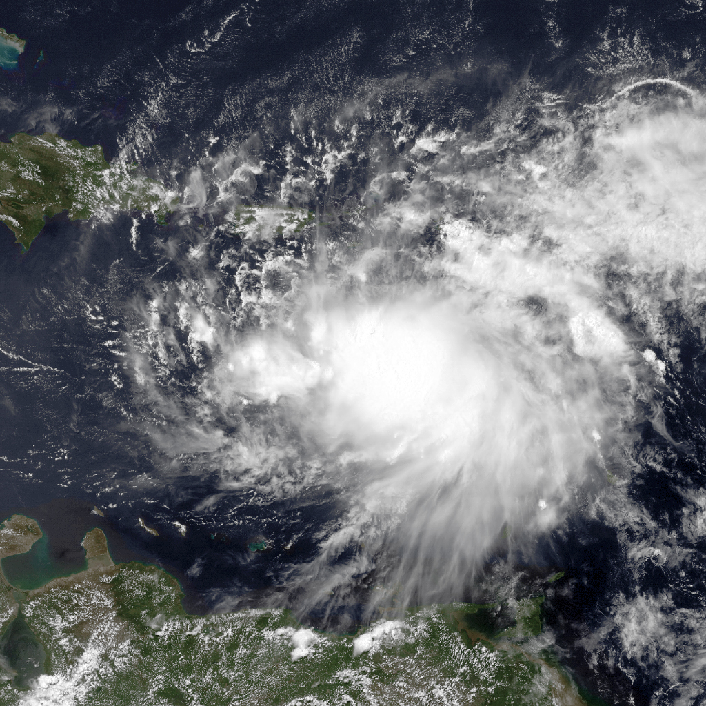
Emily became a tropical storm in the eastern Caribbean Sea and degenerated into a tropical wave near the southwestern peninsula of Haiti. Emily then reformed in the northwestern Bahamas as a tropical storm.[5]
Tropical Storm Franklin[]
Tropical storm (SSHWS) | |||
---|---|---|---|
| |||
Duration | August 12 – August 13 | ||
Peak intensity | 45 mph (75 km/h) (1-min) 1004 mbar (hPa) |
Franklin was a short-lived tropical storm over the central Atlantic that did not affect land.[6]
Tropical Storm Gert[]
Tropical storm (SSHWS) | |||
---|---|---|---|
| |||
Duration | August 13 – August 16 | ||
Peak intensity | 65 mph (100 km/h) (1-min) 1000 mbar (hPa) |
Gert was a small tropical storm that formed over the central Atlantic Ocean, passed just to the east of Bermuda, and dissipated over the northwestern Atlantic.[7]
Tropical Storm Harvey[]
Tropical storm (SSHWS) | |||
---|---|---|---|
| |||
Duration | August 19 – August 22 | ||
Peak intensity | 65 mph (100 km/h) (1-min) 994 mbar (hPa) |
Harvey was a short-lived tropical storm that made landfall with 55-kt winds in Belize and weakened as it moved across the southern Yucatan Peninsula. It re-strengthened into a tropical storm over the extreme southern portion of the Bay of Campeche before moving into southeastern Mexico, with floods causing five fatalities in that country.[8]
Hurricane Irene[]
Category 3 hurricane (SSHWS) | |||
---|---|---|---|
| |||
Duration | August 21 – August 28 | ||
Peak intensity | 120 mph (195 km/h) (1-min) 942 mbar (hPa) |
- Main article: Hurricane Irene
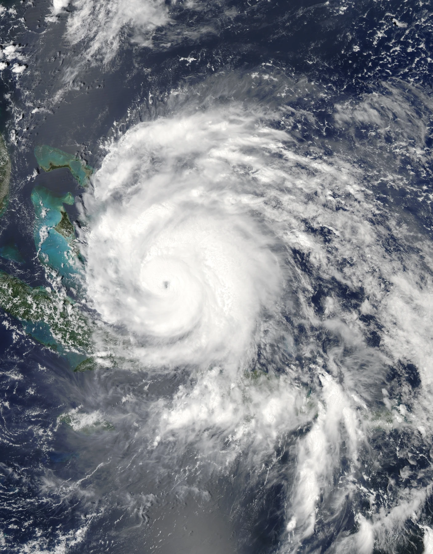
Irene hit Crooked, Acklins and Long Island in the Bahamas as a category 3 hurricane (on the Saffir-Simpson Hurricane Wind Scale) but gradually weakened after crossing the Bahamas. It made landfall in North Carolina as a category 1 hurricane and caused widespread damage across a large portion of the eastern United States as it moved north-northeastward, bringing significant effects from the mid-Atlantic states through New England. The most severe impact of Irene in the northeastern United States was catastrophic inland flooding in New Jersey, Massachusetts and Vermont.[9]
Tropical Depression Ten[]
Tropical depression (SSHWS) | |||
---|---|---|---|
| |||
Duration | August 25 – August 26 | ||
Peak intensity | 35 mph (55 km/h) (1-min) 1006 mbar (hPa) |
Tropical Storm Jose[]
Tropical storm (SSHWS) | |||
---|---|---|---|
| |||
Duration | August 27 – August 28 | ||
Peak intensity | 45 mph (75 km/h) (1-min) 1006 mbar (hPa) |
Jose was a short-lived tropical storm of non-tropical origin that passed a short distance west of Bermuda.[10]
Hurricane Katia[]
Category 4 hurricane (SSHWS) | |||
---|---|---|---|
| |||
Duration | August 29 – September 10 | ||
Peak intensity | 140 mph (220 km/h) (1-min) 942 mbar (hPa) |
Katia was a long-track, classical Cape Verde-type hurricane that attained category 4 status (on the Saffir-Simpson Hurricane Wind Scale), but remained over the open Atlantic Ocean throughout its lifetime as a tropical cyclone. However, as a large and powerful extratropical cyclone, Katia produced hurricane-force wind gusts over much of the northern British Isles, which caused some damage and loss of life.[11]
Unnamed Tropical Storm[]
Tropical storm (SSHWS) | |||
---|---|---|---|
| |||
Duration | September 1 – September 2 | ||
Peak intensity | 45 mph (75 km/h) (1-min) 1002 mbar (hPa) |
As part of its routine post-season review, the National Hurricane Center (NHC) occasionally identifies from new data or meteorological interpretation a previously undesignated tropical or subtropical cyclone. The NHC re-analysis of 2011 has concluded that a short-lived low that passed between Bermuda and Nova Scotia from 31 August to 3 September briefly had sufficient tropical characteristics to be considered a tropical storm.[12]
Tropical Storm Lee[]
Tropical storm (SSHWS) | |||
---|---|---|---|
| |||
Duration | September 2 – September 5 | ||
Peak intensity | 60 mph (95 km/h) (1-min) 986 mbar (hPa) |
- Main article: Tropical Storm Lee (2011)
Lee was a tropical storm that evolved into a subtropical cyclone before making landfall in southern Louisiana. Lee and its remnants contributed to heavy rainfall and extensive flooding over portions of the eastern United States.[13]
Hurricane Maria[]
Category 1 hurricane (SSHWS) | |||
---|---|---|---|
| |||
Duration | September 6 – September 16 | ||
Peak intensity | 80 mph (130 km/h) (1-min) 983 mbar (hPa) |
Maria formed in the eastern Atlantic Ocean and brought tropical storm conditions to portions of the Lesser Antilles. Maria then became a category 1 hurricane (on the Saffir-Simpson Hurricane Wind Scale) as it recurved through the northwestern Atlantic before it made landfall in Newfoundland as a strong tropical storm.[14]
Hurricane Nate[]
Category 1 hurricane (SSHWS) | |||
---|---|---|---|
| |||
Duration | September 7 – September 11 | ||
Peak intensity | 75 mph (120 km/h) (1-min) 994 mbar (hPa) |
Nate meandered over the Bay of Campeche for a day or so and briefly was a category 1 hurricane (on the Saffir-Simpson Hurricane Wind Scale). It then moved inland over eastern Mexico as a weak tropical storm.[15]
Hurricane Ophelia[]
Category 4 hurricane (SSHWS) | |||
---|---|---|---|
| |||
Duration | September 20 – October 3 | ||
Peak intensity | 140 mph (220 km/h) (1-min) 940 mbar (hPa) |
Ophelia was a tropical storm when it was near the northern Leeward Islands, and became a category 4 hurricane (on the Saffir-Simpson Hurricane Wind Scale) when it passed to the east of Bermuda.[16]
Hurricane Philippe[]
Category 1 hurricane (SSHWS) | |||
---|---|---|---|
| |||
Duration | September 24 – October 8 | ||
Peak intensity | 90 mph (150 km/h) (1-min) 976 mbar (hPa) |
Philippe was a long-lived tropical cyclone that twice became a category 1 hurricane (on the Saffir-Simpson Hurricane Wind Scale). Although it lasted for about two weeks, Philippe did not affect land.[17]
Hurricane Rina[]
Category 3 hurricane (SSHWS) | |||
---|---|---|---|
| |||
Duration | October 23 – October 28 | ||
Peak intensity | 115 mph (185 km/h) (1-min) 966 mbar (hPa) |
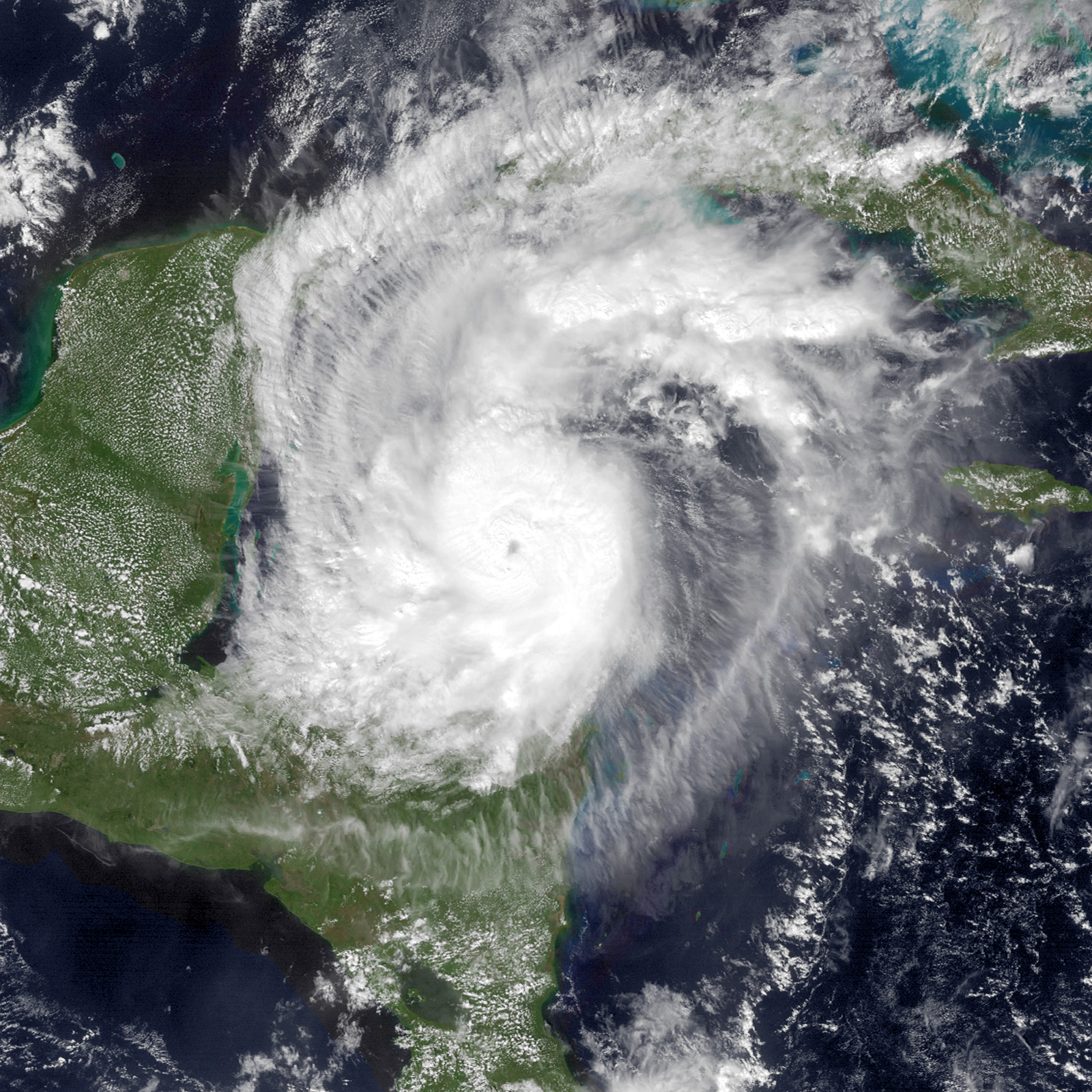
Rina was a typical October major hurricane that formed in the western Caribbean Sea and moved toward the Yucatan Peninsula. However, it weakened significantly prior to landfall on the Yucatan Peninsula as a tropical storm and it dissipated near the Yucatan Channel.[18]
Tropical Storm Sean[]
Tropical storm (SSHWS) | |||
---|---|---|---|
| |||
Duration | November 8 – November 11 | ||
Peak intensity | 65 mph (100 km/h) (1-min) 982 mbar (hPa) |
Sean was a tropical storm that formed between the Bahamas and Bermuda. The cyclone produced a brief period of tropical-storm-force winds in Bermuda as it moved nearby.[19]
Storm names[]
The following names were used for named storms in the North Atlantic in 2011. This is the list taken from the 2005 season with the substitution of Don, Katia, Rina, Sean, and Whitney for Dennis, Katrina, Rita, Stan, and Wilma, respectively. The names Don, Katia, Rina, and Sean were used for the first time. The names not retired will be reused for the 2017 season. Names that were not used are marked in gray.
|
|
Retirement[]
On April 13, 2012, at the 34th Session of the World Meteorological Organization's Regional Association Hurricane Committee, the WMO retired the name Irene from its rotating name lists. It was replaced with Irma for the 2017 Atlantic hurricane season.
Season effects[]
This is a table of all of the storms that have formed in the 2011 Atlantic hurricane season. It includes their duration, names, landfall(s) – denoted by bold location names – damages, and death totals. Deaths in parentheses are additional and indirect (an example of an indirect death would be a traffic accident), but were still related to that storm. Damage and deaths include totals while the storm was extratropical, a wave, or a low, and all of the damage figures are in 2011 USD.
Saffir–Simpson hurricane wind scale | ||||||
TD | TS | C1 | C2 | C3 | C4 | C5 |
Storm name |
Dates active | Storm category
at peak intensity |
Max 1-min wind mph (km/h) |
Min. press. (mbar) |
Areas affected | Damage (millions USD) |
Deaths
| |||
---|---|---|---|---|---|---|---|---|---|---|
Arlene | June 28–July 1 | Tropical storm | 65 (100) | 993 | Central America, Mexico (Veracruz), Texas, Florida | 223.4 | 18 (4) | |||
Bret | July 17–22 | Tropical storm | 70 (110) | 995 | Bahamas, Bermuda, East Coast of the United States | None | 0 | |||
Cindy | July 20–22 | Tropical storm | 70 (110) | 994 | Bermuda | None | 0 | |||
Don | July 27–30 | Tropical storm | 50 (85) | 997 | Cuba, Yucatán Peninsula, Northeastern Mexico, Texas | None | 0 | |||
Emily | August 2–7 | Tropical storm | 50 (85) | 1003 | Antilles, Florida, Bahamas | 5 | 4 (1) | |||
Franklin | August 12–13 | Tropical storm | 45 (75) | 1004 | Bermuda | None | 0 | |||
Gert | August 13–16 | Tropical storm | 65 (100) | 1000 | Bermuda | None | 0 | |||
Harvey | August 19–22 | Tropical storm | 65 (100) | 994 | Lesser Antilles, Hispaniola, Central America (Belize), Mexico (Veracruz) | Minimal | 5 | |||
Irene | August 21–28 | Category 3 hurricane | 120 (195) | 942 | Antilles (US Virgin Islands, Puerto Rico), Lucayan Archipelago (Bahamas), Eastern United States (North Carolina, New Jersey, New York), Eastern Canada | 14,200 | 49 (9) | |||
Ten | August 25–26 | Tropical depression | 35 (55) | 1006 | None | None | 0 | |||
Jose | August 27–28 | Tropical storm | 45 (75) | 1006 | Bermuda | None | 0 | |||
Katia | August 29–September 10 | Category 4 hurricane | 140 (220) | 942 | Lesser Antilles, East Coast of the United States, Canada, Europe | 157 | 3 (1) | |||
Unnamed | August 31–September 3 | Tropical storm | 45 (75) | 1002 | None | None | 0 | |||
Lee | September 1–5 | Tropical storm | 60 (95) | 986 | Gulf Coast of the United States (Louisiana), Eastern United States | ≥$1,600 | 18 | |||
Maria | September 6–16 | Category 1 hurricane | 80 (130) | 983 | Lesser Antilles, Bermuda, Newfoundland, Europe | 1.3 | 0 | |||
Nate | September 7–11 | Category 1 hurricane | 75 (120) | 994 | Mexico (Veracruz) | Minimal | 4 (1) | |||
Ophelia | September 20–October 3 | Category 4 hurricane | 140 (220) | 940 | Leeward Islands, Bermuda, Newfoundland, Europe | Minimal | 0 | |||
Philippe | September 24 – October 8 | Category 1 hurricane | 90 (150) | 976 | None | None | 0 | |||
Rina | October 23–28 | Category 3 hurricane | 115 (185) | 966 | Central America, Yucatán Peninsula (Quintana Roo), Cuba, Florida | 2.3 | 0 | |||
Sean | November 8–11 | Tropical storm | 65 (100) | 982 | Bermuda | Minimal | 0 (1) | |||
Season Aggregates | ||||||||||
20 cyclones | June 28 – November 11 | 140 (220) | 940 | >$16.19 billion | 96 (16) |
References[]
- ↑ http://www.nhc.noaa.gov/data/tcr/AL012011_Arlene.pdf
- ↑ http://www.nhc.noaa.gov/data/tcr/AL022011_Bret.pdf
- ↑ http://www.nhc.noaa.gov/data/tcr/AL032011_Cindy.pdf
- ↑ http://www.nhc.noaa.gov/data/tcr/AL042011_Don.pdf
- ↑ http://www.nhc.noaa.gov/data/tcr/AL052011_Emily.pdf
- ↑ http://www.nhc.noaa.gov/data/tcr/AL062011_Franklin.pdf
- ↑ http://www.nhc.noaa.gov/data/tcr/AL072011_Gert.pdf
- ↑ http://www.nhc.noaa.gov/data/tcr/AL082011_Harvey.pdf
- ↑ http://www.nhc.noaa.gov/data/tcr/AL092011_Irene.pdf
- ↑ http://www.nhc.noaa.gov/data/tcr/AL112011_Jose.pdf
- ↑ http://www.nhc.noaa.gov/data/tcr/AL122011_Katia.pdf
- ↑ http://www.nhc.noaa.gov/data/tcr/AL202011_Unnamed.pdf
- ↑ http://www.nhc.noaa.gov/data/tcr/AL132011_Lee.pdf
- ↑ http://www.nhc.noaa.gov/data/tcr/AL142011_Maria.pdf
- ↑ http://www.nhc.noaa.gov/data/tcr/AL152011_Nate.pdf
- ↑ http://www.nhc.noaa.gov/data/tcr/AL162011_Ophelia.pdf
- ↑ http://www.nhc.noaa.gov/data/tcr/AL172011_Philippe.pdf
- ↑ http://www.nhc.noaa.gov/data/tcr/AL182011_Rina.pdf
- ↑ http://www.nhc.noaa.gov/data/tcr/AL192011_Sean.pdf